Nearly everyone has access to a digital camera now days. Even the kids use the one on their phones in ways none of us older guys ever even thought of. Each photo taken is a "file" stored somewhere with a name.
Unfortunately, there are still many, many types of files. Meaning many different styles for storing the same data - depending upon manufacturer of the camera and whether you want "quality" versus "small size."
Fortunately, they do have something in common and that's a very small area accompanying the photo data file called a "header." It's a secret place to store "directions" in the file, to tell the computer how the data is organized so it can get it back out. This is also the place that cameras can store the date and time the photo was taken. AND, the place to "sneak in" GPS data!
Some cameras even store GPS data automatically - mine does not, and probably neither does yours. We do have another way, however, and that's to get the latitude and longitude from another source and have your computer "poke" them into the picture file when you get home.
Also, as I've spoken about before, I was naive enough to buy a Lowrance XOG GPS without realizing that it used "non-standard" methods in storing its tracks.
 The "standard" is to automatically store the latitude, longitude, time and sometimes altitude in a long list every few seconds. That way, your mapping software just plots a dot for each of the thousand records in the list, and voila you have a trail.
Unfortunately, the Lowrance XOG decided to strip off the time from the record so you can tell where you were but NOT when you were there. So you can't tie your photos to your GPS using TIME! [The XOG doesn't save its file in the standard ".gpx" format either; but there is an easy way to get around that - in another post]
Fortunately, a saving grace, albeit extremely annoying, is that the XOG does store the time when you press the button and save a Waypoint. That's just an expanded track point saved in a separate file, so you can record a "flag" of a "special" place you wanted to remember.
 The problem was that absolutely none of the programs available to "poke" the coordinates into photos even looked at the waypoints, they only used the tracks. That's where GPicSync comes in.
When I discovered the problem with the Lowrance XOG, I had the temerity to write to François Schnell at his home in France. He agreed that it would enhance his program to add that functionality and sent me the beta copy. It works great! Once you drill it into your head that you MUST manually set waypoints every time you get off your bike to take a picture!!!
I can now geocode my photos - and you can too:
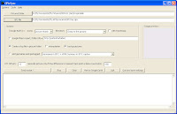
- Obtain and install GPicSync beta 1.27
- Put the photos you want to geocode in a separate folder
- Start GPicSync
- Fill in the path to your photo folder
- Fill in the path to your .gpx file (which includes the track and waypoints)
- Set any "offset" to correct the time zone differences (-8 is the difference between GMT and PST)
- Change the "geocode only" value from 300 to about 600 to allow a better fit for waypoints instead of tracks
- Press Synchronize! Sit back and watch it work.
The only thing I've learned the hard way is that: You have GOT to save your own waypoints every time you take a picture; AND, if you stop for more than a few moments, it's best to save a waypoint both when you stop your bike AND when you finish taking pictures. That prevents the next waypoint from "stealing" photos from the end of the previous shooting session.
The program works great. It is the only one I can find for people with GPS units which don't store the time inside the track file. And, its interface with Google Earth (GE) opens up tons of other things you can do.
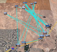
One small deficiency is that even though the .gpx file does have a good track (albeit without the times) GPicSync doesn't use it when outputting to GE. The resulting plot in GE therefore looks a bit funny - although with a neat .kml editor like jEdit you can.... But, that's another post...
I think I'll write to Mssr. Schnell again.
2 comments:
GpicSync ? There is a better solution !
I tried Geosetter 3.0.14 (http://www.geosetter.de/en/).
It is far better respect other like GpicSync. Its GUI interface is well done and has a lot of features.
Siply to use, almost nothing to do to configurate it. In a snap all the photo are geotagged using the data from logger unit.
In a word: wonderful freeware !
Ciao
Danilo
Mssr. Danilo... I do NOT agree that Geosetter is a better solution, for what I believe is the majority of GPS users. I found that, while it does have some very handy features (which I wish GpicSync had), it does NOT utilize the WAYPOINTS which have been set to geocode the photos - only track data. Many, if not most, new GPS units strip off the "time" element from track data as they port over to memory cards making them useless to correlate with timed photos. GpicSync didn't do it either until Mssr. Schnell gratiously added the feature upon my request.
Additionally, Geosetter is much more complicated to learn and use - although much more extensive. I DO believe, however, that it would be a useful program to have on your computer IF you have a GPS unit which leaves the time element in the track data (unlike my Lowrance XOG) and you have a better than average ability with computer usage.
Now that I have my original problem solved, I think I will give it another try.
Post a Comment
Thanks for taking the time to leave a comment. I will, of course, be moderating all comments to make sure (a) they conform to the standards of good taste set forth by Offroading Home; and (b) nope that's pretty much it.