Thursday, June 30, 2011

GEO-tography: Macro

If it's one thing that senior ATV riders have along offroad trails, it's the proclivity to stop and take a picture of things we see and want to remember or show those back home. I call it: Geo-tography – photography of our "geo." Not that any of us have any grandiose ideas that we're going to become famous photographers or anything; but, just capable enough so that our digital cameras weren't a total waste of money.

The way I figure it, if I just keep looking at good pictures for long enough some of it may rub off on me – even if it has to be sub-consciously. So, when I saw a group of photos using the "Macro Technique" I thought that they might could use a closer look.

Macro photography is all about capturing things up close, usually involving special lenses designed specifically for this task. However, I notice that most new digital cameras come with some sort of "macro" setting, although usually require some actual reading of the instructions in order to find it.

Sunday, June 26, 2011

GEO-tography: Sunrise

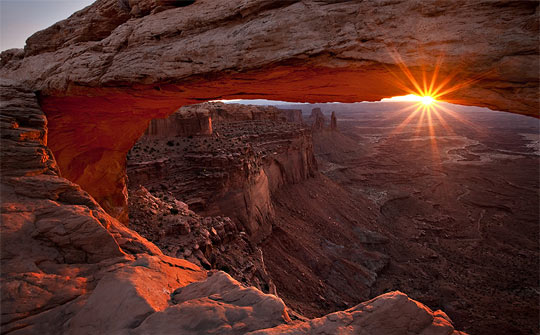
Sadly, the most beautiful part of the day occurs before many people wake up, but thank goodness there are those early rising photographers or most of us wouldn't even know what it looked like. Those intrepid souls are willing to set the alarm clock a bit early in order to get their traveling over with in order to be in actual position to capture the beauty of a sunrise so others can see.

They may have either ridden their ATV's offroad in the dark or (heaven's forbid) actually slept on the ground in order to have their finger poised over the shutter button as the first ray of light proclaimed the advent of the promised new day.

Offroading Break

The call of the off-road beckons as a siren from the south, so a short break with our ATVs is in order. Until next week enjoy a couple of posts of GEO-tography.

Thursday, June 23, 2011

Jumbo and Lime Wilderness BLM Meetings

Never willing to leave well enough alone, the BLM wants to do a face-to-face with the offroaders around the Gold Butte area - and any who ever seek to go there.   [Previous post with wilderness map: Jumbo Wilderness-Pierson Gap.]

Ostensibly they want to hear your opinion about the two existing wilderness areas already on Gold Butte; however, we know all too well the agenda's and modus operandi of the Las Vegas office. They are actually mandated by law to hold "scoping" meetings, even though absolutely nothing (which can't be rationalized away) needs to be listened to or followed.

What must happen, however, is large numbers of off-road riders show up at: Bunkerville Community Center June 27, 2011 6 PM, Overton Community Center June 28, 2011 6 PM and Mesquite City Hall June 29, 2011 6 PM to demand answers to substantial questions in front of the press. And somebody should make certain that the local press attends.

Yea, I know that the two areas are ALREADY wilderness areas and that nothing short of a massive legislative recall and congressional Un-"wilderness-izing" the area can be done about it; but, these scoping meetings are the place to try and "entice" (or shame) the managing agency (in this case the BLM) into making implementation rules less prejudicial to the senior community and onerous to offroaders.

The backcountry rambler over at the "Save Gold Butte" blog thinks people should talk about "weed treatment for invasive species and developing interpretive information to educate the visiting public about the resources and history in the area." Those topics are, indeed, within the realms of the wilderness guidelines and I'm not saying they shouldn't be addressed. Although, I don't know which "visiting public" he has in mind – there is no visiting public… this is wilderness. Unless you count an infinitesimally small number of hikers.

However, the press will be there and, IMHO, at least someone should voice the intense disdain over the arrogance and incompetence of the implementers (read Harry Reid and his either incompetent or deceptive staff) who exhibited such obvious discrimination against the senior population which for years frequented the area.

What someone needs to demand is an answer why the boundary of the Jumbo Wilderness was drawn a matter of yards too far to the east to allow continued access to Cottonwood Canyon through the Pierson Gap trail! The final tiny section of the trail, runs almost parallel to the border between two very popular and still open riding areas, through rock and has been used for hundreds of years.

By precedent, a right-of-way for the existing historic trail should have been accounted for like has been done in countless other wilderness designations around the country. I'd also like to know what procedural or legislative method there is to re-align the border so as to provide multi-use through that minuscule portion of the existing trail. Or, in the interim, what alternative route can circumnavigate the closed portion.

Doing this in the off riding season, the time when there are least numbers of senior users in town to defend themselves, (which by the way is another question to demand an answer for) – what a deceptive, behind-the-back time to choose for your "scoping meeting" Ms. Marr – for shame!

Monday, June 20, 2011

Offroad: Mesquite - CCC Cabins

A bit stir-crazy from all the rain and snow, Gordon and I took our rigs up to Toquop Wash for the first time this season. There are many nice things to see up the wash, and several areas which are quite challanging; but, as rides go, much of is a bit nondescript so sort of falls down the priority list a bit.

Beginning up at the water-tank road trailhead, will take you to Toquop by a trip up and over Flat Top Mesa. You'll need to negotiate opening and closing heavy gates on an incline on both sides of the Mesa; so, unless the Mesa is an actual destination, most riders prefer a little easier access to the wash.

Thursday, June 16, 2011

GEO-tography: Spring

You know, if I don't soon post these photos that I've been saving about spring – it won't be spring any more. This year, we've got all the plants in but they haven't gotten out of their shock yet from all the snow and cold weather up here at summertime snowbird headquarters. By the time we take off our coats we will have missed spring entirely.

However, there must have been spring somewhere because look at all the examples of spring photography I have found. Our goal here is NOT so much become expert photographers BUT to get some ideas of how to make our own snapshots a bit more… let's say… "showable."

All of these, of course, are examples of what I call Geo-tograpy. They aren't always Geo-coded but are most always of our offroad Geo-graphy. As always, be a bit patient as they load because they are full photos. And if you've got some examples of spring geo-shots you'd like to share, post about them in the comments.

Wednesday, June 15, 2011

Obama Utah Land Grab

I have received information from USA-All that Obama is planning a "LAND GRAB" in Utah and the west similar to what Clinton did in his last ditch "scorched earth" method just before exiting the office.

The offroad group wrote: "Utah's Congressmen Bishop and Chaffetz and Senators Hatch and Lee jointly submitted a bill intended to prevent President Obama from creating HUGE national monuments in Utah. Last year Congressman Bishop uncovered internal BLM documents that appeared to show the Obama administration was considering an attempt to create 14 national monuments across the west including in Utah. Utah is still reeling from the politically motivated creation of a 1.9 million acre monument in the Escalante Grand Staircase by President Clinton in 1996."

The public lands group has begun trying to convince the delegation to opt Utah out in a similar fashion to what Wyoming did in the 1950's. I'm not sure what that fully means but if it will prevent Obama from pulling the atrocity that Clinton pulled – Offroading Home is all for it.

Saturday, June 11, 2011

Colorado Backroads: Offroad Trails Map Update

Actually, some time ago I spent what seemed like a year one month completely going through the Colorado Master Map and updating it to include the trails in the book "Colorado Backroads & 4-Wheel Drive Trails" by Charles A. Wells and published by FunTrecks.

The book contains descriptions for trails through colorado's most scenic areas so I was excited to see how they traversed the actual globe. I quickly began experiencing difficulties almost around every corner. Wells sometime used, lets say, "alternate" road and area names – at least different than I could find in any of the databases.

I could see that the book had only sparse GPS coordinates but most of the time with even just a few you can follow Google Earth satellite images along the trails – not to be. Colorado is covered in snow much of the year and a canopy of green the rest of the time so trying to follow trails from the outer atmosphere is maddening.

So, even though it was updated months ago, and I decided to go ahead and publish what I could to the server; I, none-the-less realized people would need some explanation about the different format these trails required and planned a blog post. Which post, I'm sad to say, got delayed… until now.

Tuesday, June 7, 2011

Offroad: Gold Butte - Devil's Cove, Horse Springs

The 2011 winter offroad riding season in southeastern Nevada, well at least the Mesquite area, has been an unusually - read frustratingly - wet time especially for all our ATVs held hostage under tarps and in garages. Don't get me wrong, we're happy for the all the citizen locals who are out dancing in the street for the dust-quenching moisture. Just sayin' …

Gordon and I braved the dark clouds in the morning, perhaps believing that: "if you go it will stop" or some such erudite sapience, and saddled up the CanAm and Yamaha to head for "The Butte." After all, one needs to ride it as often as one can before the Reid/Holecheck coalition closes it all off to seniors.

Friday, June 3, 2011

NEW: Bryce Canyon Trail System

You know, with age, I find it increasingly difficult to do two things at once. I learned a term in my youth, back when things called computers were invented – it's called "time sharing." Afterwards, the womens movement claimed the prior discovery rights to the activity; they said it had been inherent in the gender to "multi-task" since the time of Eve.

I used to be able to do it like a whiz, you know: drive and read a map, listen on the phone and continue reading mail, dictate a letter and drive to work, walk and chew gum… I used to be able to juggle navigating an ATV over a single-track, watching a GPS trac, scanning for photo ops, listening to a CD and pointing out items of interest to companions all at one time. Well, I still can do the "gum" thing but it's difficult to both work on building trail maps and write blogs at the same time.

However, have I got a deal for you today! A rider from southern California named Randy began communicating with me several months ago about some rides he had taken up in Utah, around the Bryce Canyon area. Over the last three or four months, we've been communicating about the area and he has been able to send in three great GPS tracks for those of you who want to ride the area with your offroad machines.

Wednesday, June 1, 2011

Salazar Backtracks On His Land Grab - For Now

Offroading Home has just received word Wednesday morning that Secretary Salazar will back off on his "Wild Land" grab … at least for now. The letter we received from USA-ALL is included after the jump.