Saturday, February 28, 2009

Extra Ride 5 - Gold Butte Byway

One would think that we had a "fixation" or something on this ride. Truth is that it contains a lot of the things people want to see.   [For a free Google Earth file of this route see: Extra Ride 5 - Gold Butte Byway]

So, when I describe to someone who wants to take me riding, the various options; this ride is often selected. And, it makes no never mind to me because every time I go I see something new and this ride was no exception.

He who has seen one cathedral ten times has seen something; he who has seen ten cathedrals once has seen but little; and he who has spent half an hour in each of a hundred cathedrals has seen nothing at all.”
Sinclair Lewis

I won't bore you with another blow-by-blow, you can read about the directions in a couple of posts back. By now you know how to get to Whitney Junction trailhead, where the byway starts.

We took an SUV this time, because three wanted to go with only two rigs. BJ, the manager of the condo's, has a great one- and real flashy.

We stopped at "first rock" to see the petroglyphs. They are still there and I can say, have no further damage in the three years we've seen them, despite being the most heavily visited. Put that in your pipe fiends of Gold Butte! They remain the ONLY glyps that seniors who don't hike can still see, after this years BLM debauchery.

At the Ghost town of Gold Butte we met a couple on rigs who have lived their whole lives in the Bunkerville area. They knew all about the attempted idiocy of trying to close down the whole area this last year.

They also had met William Garrett, the old-timer who lived his life on the butte and is buried there with his buddy - "the long and short of Gold Butte."

His father had related a story to him about getting to shoot Garrett's well cared for Colt 45. Garrett loaded the pistol, tossed out a can and watched as all the boy's shots missed.

In mock disgust, he took back the gun, loaded it and popped off six rapid-fire shots making the can "dance" with every shot.

They also took us around to an old mill stone which the Chinese workers used to grind ore with. It's made out of one of those huge "pudding" like conglomerate rocks and looks nearly identical to pictures of those olive presses in Italy.

None of the cacti are in bloom yet, but the air was cool and smelled clean. We turned back up North and continued the ride. When we reached Mud Wash we turned East and back to Devil's throat completing the circuit.

Friday, February 27, 2009

Ride 18 - Flat Top Mesa

"There ain't no view grander" around Mesquite than Flat Top Mesa, and I've got the pictures to prove it. [For a free Google Earth file of this route see: Ride 18 - Flat Top Mesa]

Despite there being some steep sections, dad decided my description was too enticing and wanted to go. Besides it fit in with our long time goal to "get down to the river (Toquop Wash)."

West on Pioneer then North (right) on Ben Franklin will bring you to the water tank and the Flat Top Mesa trailhead. A large open turnaround with a trail leading over a "berm."

As mentioned in a previous post, a "history of the mesa" describes how early settlers used to pasture their horses during the night on the mesa as it had only one way up. Later the trail was widened several times by grazing rights holders, uranium miners, power-line builders and a person with an M8 Caterpillar.

The graded road is wide, but does get a bit steep. There are only two issues I have with it. One is the idiotic placement of the gates on the steepest, narrowest section of the road. If you don't have a good parking brake - DON'T go up it. You need to hang on for dear life to exit your rig, piton up to the gate, let it drag you open under its weight, remount and re-park then do it all over again to shut the bloomin' thing.

Truly the hardest part of the ride is getting through the blasted gate! Once on top... the only choice is to go right or left. We took "right" and soon realized that the mesa is "way more" bigger than it looks from below.

There are rustic corrals, cairns, watering holes, rain gauges, funny looking cacti, sand dunes, sharp drop offs and, yes... the bazillion volt power-line that runs to Vegas jumps up to the top on one side and back down the other.

There's a trail that runs all around the perimeter of the mesa. And, remember I said I had "two issues"? That's the other one. The trail gets way too close to the edge to suit me. In more than a few places the road's shoulder is the air!

The vista's are incredible! The only drawback that we had was that the day was overcast and smoggy (yes Mesquite has a smog problem) so our photos weren't what we wanted.

You can see into Utah, Arizona and Nevada - and, we could finally understand just why we got "lost" on our attempts to find a connecting trail North out of the Mesa Boulevard trailhead.

On the East side you get an arial view of Dell Webb Mesquite, and if you spit real hard you can hit Gordon's neighbor's roof.

When you’re traveling, ask the traveler for advice, not someone whose lameness keeps him in one place.”
Rumi

Be sure and click the photo icons on the Google Earth file available in the link above. This time I've loaded it with panoramic photos that I stitched together of the view from several areas.

In fact, I'll quit yapping and let you go do it now - you don't want to miss this one! [p.s. once we got all around the mesa it was too late to go to the river... again.]

Thursday, February 26, 2009

Extra Ride 4 - Flat Top Mesa/Toquop Wash

The best thing about being jealous is getting even. Last week Gordon and Charlie took a ride to the top of Flat Top Mesa and I was jealous.   [For a free Google Earth file of this route see: Extra 4 -Flat Top/Toquop]

This week, with nothing else to do, Gordon took me on the trail. We trailer'd up to the Flat Top Mesa trailhead by the water tank and took off over the berm.

Part of the intrigue is that from the city or freeway there doesn't look like there's any way in (you know where) that anything can "git up there." But, as it turned out, there is an unexpected trail to the top which doesn't even require pitons or carabiners.

Near the top there is a gate which must be opened, then voila you're there. There's few vistas any better, of the Mesquite-Bunkerville valley and Virgin River, thanks to Harold E Wittwer. He, along with his dad and other "old timers," cut and widened the road for the use of pasturing cattle, and are now keeping it open for recreational use.

There is a post with a container of handouts at the top containing the whole story. Its worth the time to visit the several places he mentions. We then went across the mesa to the other side, through the gate and down into Toquop Wash.

It's a nice ride, as washes go, to the North through multi-colored cliffs, dunes and sage brush. The goal was the powerline and from the ground IT'S REALLY BIG.

There is also the natural gas pipeline right-of-way under the lines with signs prohibiting riding it due to the desert turtles. But while you're sitting there squinting at the sign to read the small print, the power lines are buzzing above your head - pacemakers beware.

Feet beyond the powerlines there is a crossroad which begins the loop we took. To the left you must rapidly go down into a deep wash directly in the path of the pipes, and you wonder where in (you know where) did they go? They must have "taken a substantial dive" under the same canyon and back up the other side.

From then on to the mountains in the distance, it is like a "Cactophile's" dream. Nearly every cactus and yucca we've seen in this whole area is congregated here - and doing extremely well. The only two missing are the "pencil Cholla" and "Mojave Yucca."

There were the largest examples we've seen of the three Prickly Pears: normal, Beaver Tail and Mojave (grizzly bear). There were Silver, Gold, and Buckhorn Cholla's along with a clear example of the hybrid as yet unidentified.

Huge barrels dotted the landscape and nearly filled one whole mountainside. And even many examples of the "cluster barrel" (cotton top) were intermingled with strawberry hedgehog. The Joshua Tree Yucca's weren't as thick as we've seen them elsewhere but were healthy. And there was another yucca which I haven't seen before in the area.

We turned North along the mountain line looking for old mines which were on our map. But, there were NONE to be seen, even old tailing's. We passed several springs and stopped at some crumbling old rock cabins. The longer we analyzed them the more significant a feat their existence became. They were very well built from shaped, flat, non-native flagstone with poured concrete footings and mortar.

They are very small, one-room with attached "sleeping porch," one or two windows and "root cellar" built in 1942 - according to the inscription in the cement. One rumor holds that they were where the mayor of Los Vegas used to bring his "lady friends" but who knows? They are definitely too upscale to be "line cabins" or cattle shacks.

All through the area we saw cattle grazing, although on what I have no idea. One bull was the most sorry looking animal we have yet seen but I was too busy being astonished to remember to take a picture.

The trail got more narrow and rocky. At Gourd Spring there was a huge stock tank with a brisk flow of water, moss but NO goldfish! (It desperately needs some). Close by we saw yet another attempt at "re-forestation" using a black plastic "pop-bottle" like thing pushed into the sand, ostensibly next to some plant. The problem is that of all that we've seen, nothing ever has been growing and the bottles are all empty. Looks like a bunch of institutionalized littering to me.

At the tip of our circle, Gordon pointed out what looked a bit like "petroglyphs" on a rock. I don't know. They were not chipped onto the dark desert varnish like others in the area and were pretty nondescript shapes.

Kilometers are shorter than miles. Save gas, take your next trip in kilometers.”
George Carlin

The ride back down to the powerline crossroads was rocky and long. Then going down Toquop wash seemed more difficult than the other direction. Perhaps it was because it was getting dark and our posteriors had just ridden 53 miles.

Wednesday, February 25, 2009

Using "OffroadingHome" KML Files

I have been asked several times how to actually use the files available free on this blog. Using them in Google Earth is easy - just click on the link and select "open"! Nothing to it.

However, until now I haven't been able to give a specific answer about how to use them inside your own GPS unit. Mostly because every manufacturer has their own proprietary file formats and instruction manuals. And also because I knew of no adequate (read reliable and free) way to convert my .kmz files to your units file types.

Today, I became aware of: "GPS Trackmaker Free." It is NOT a very "flexible" program, nor is it always "intuitive," (to a US American) nor does it support EVERY GPS unit; HOWEVER, it isn't terribly difficult to learn, it DOES read .kml (Google Earth) files, it does support a lot of brands and, most importantly, it does support the open source standard .gpx files.

All of this makes it a very useful, FREE, program which will PROBABLY do the trick, IF you have just a little bit of computer savvy. So, Charlie, here it is - finally!

Here are the steps that I have used several times now to download a track file from this site, convert it into my Lowrance GPS file type (.usr) and then read it with the Lowrance mapping software. It should also work with other brands such as Garmin and Magellan (some), and does provide an apparently unique interface between .gpx, .txt, and .kml file types which can then be used in other "converters."

The procedure is a bit circuitous and uses both the Google Earth and GPS Trackmaker programs. "Earth" to change the file from compressed to un-compressed (.kmz to .kml) and "trackmaker" to change it from .kml into a, hopefully, useable type for your GPS unit (ie. .kml to .usr).
  1. Download and install Google Earth (4.3 version) and learn how to "OPEN", and "SAVE AS" a track file into the .KML format. The 4.3 version doesn't have the bugs that the new 5.0 version has.

  2. Download and install GPS Trackmaker Free and familiarize how to "OPEN" .kml files and "SAVE AS" the file type of your GPS unit (your literature should tell you what it is).

  3. Create a new working folder somewhere that you can find easily, like your desk top.

  4. Open the "OffroadingHome" blog and find the trail you want to convert. Then click on the file link and choose "OPEN" when requested.

  5. The file will open Google Earth and will be listed in the "temporary places" folder (above). Cursor over the file name such as "16th Day.kml," RIGHT-click the link and choose "SAVE AS."

  6. The "save file" dialog box will open and will need some changes.
    First, the "save as type" must be changed from .kmZ to .kmL;
    Second, the "file name" will have a .kml ending (16th Day.kml) which must be taken OFF (as shown);
    and Third single-click on the conversion folder you have set up (in order to highlight it as the place for it to go) then click "Open" followed by "Save."

  7. Google Earth will have now saved the compressed .kmz file from my site to an un-compressed .kml file in the folder on your computer. Now you can close Google Earth and open GPS TrackMaker.

  8. From the menu at the top select "File > Open File." Then from the "Open File" dialog box, navigate to your conversion folder, select your file and press "Open." The file will now be inside TrackMaker and ready to convert. In this example you can see the track and two waypoints.

  9. Now, go back up to the top and select "File > Save As" to open the standard dialog box. You MUST change the "Save as Type" box to the file type that YOUR GPS expects, in my case the Lowrance ".usr" type. Also navigate to the conversion folder and set the file name the way you want it.

  10. Press "Open" then "Save" and my file has been converted into your GPSs type.

  11. Now, follow the directions that came with your GPS unit to move the file you just created back into your GPS unit. You should also be able to open the file with any mapping software that came with your unit.

Some people without brains do an AWFUL lot of talking!”
L. Frank Baum
The Wizard of Oz

The file type ".gpx" is known as the standard open source protocol for geo-coding. Many other programs (including Google Earth), and some GPS units will accept a file in this format.

The whole process of doing this is sort of like an enema - "it feels sooo good when it's over." But it does work and the next time you go riding you will have the track to follow and waypoints to look for. I would appreciate comments from anyone who uses this for their units - or anyone who had a better way.

Sunday, February 22, 2009

Trip to Arizona

I took a quick weekend trip to Hidden Valley Arizona to check on the desert property down there.

It's still there, no worse for the neglect we've been giving it. But, the people who live there are struggling. Land values which had been ridiculously exhorbitant, have crashed and people who had rushed in for the "land grab" with NO money down have been forclosed on.

Forgive me my nonsense as I also forgive the nonsense of those who think they talk sense”
Robert Frost

Typical to the area, those evicted "looted" the place to bare walls before they just walked out! It's hard to decide which is worse the greedy thieves who act all suprised when they buy what they can't afford or the brain-dead idiots who loaned them the money expecting property inflation to pay the premiums.

I attended a water company annual meeting which was an eye-opener. Apparantly water has not ceased to be one of the major contentions of the desert. And speaking of desert, it is really obvious that the Phoenix area desert is different than the Mesquite area desert. Some of the cactus are the same but many are very different.

It was interesting to pass, yet again, over the Boulder (Hoover) Dam. They've been working on a new bypass ever since 9-11 and haven't got it done yet. In their defense, however, it did blow down once. All the access roads and ramps have been done for awhile now, they're just waiting on the bridge. The towers are up and they're stringing the cable-stays and pumping cement for the roadway arch supports.

At any rate, even though the Lowrance GPS map is several years out-of-date and the company hasn't bothered to update it, my XOG did come through. A lot of the time my "dot" looked like it was out on bare earth instead of a paved road; but, it kept shouting directions at me all through the crazy Phoenix freeway maze.

Despite the fact that the Lowrance XOG has incompetent software engineering in some areas, and the companies customer service is basically non-existant, the little unit has a good screen size, is portable and keeps slugging away.

Wednesday, February 18, 2009

Extra Ride 3 - Gold Butte Byway

In a previous post I mentioned a friend who went riding with us. He is from the Monte Cristo area and rides a fully loaded side-by-side.   [No map file available for this ride: see ride 11]

We arranged to spend the day exploring Gold Butte and probably the best initial exposure is to follow the Gold Butte Backcountry Byway. He brought a friend as well and we all trailer'd to the Whitney Junction trailhead.

The road, which had been paved (well almost) up to the junction, now becomes only graded dirt, but is still quite nice. SUVs, Jeeps and ATVs all share the road.

Shortly after the first cattle guard is the fairly large Mud Wash which leads into the Middle Gold Butte ATV area, past the Mud Wash petroglyphs, through the "narrows" and out onto the flats above Lake Mead.

I mention that just for "bearings" because the byway continues South to the crossroads at Devil's Throat. This is the beginning of a loop around a mountain range; and, although we will presently continue South we will end up right back here.

A sign informs about the 2005 Tramp and Fork fire which took out this whole area to the West of the road. Reportedly started by lightening but they are blaming "non-native" grasses for keeping it going (huh?). It seems to me that fire doesn't have a clue about its fuel's ethnicity.

Even four years hasn't begun to re-establish the area. The contrast between the unburned area on the left and the burned area on the right speaks volumes for the beneficial effect of firebreaks - thank heavens the fiends of Gold Butte hadn't closed and obliterated the road.

The road, although un-maintained dirt, rides "fast," but who wants to? The vistas are incredible! As you get closer to the old Gold Butte town site, the rocks become very unusual. They are globular, and round. Up close it is clear that they are chips of granite like rock, conglomerated into a "cement like" matrix.

A few old pieces of mining equipment reveal that you have arrived. There are also the grave markers of William H. Garrett and Arthur S. Coleman, two early settlers who lived and died in the area. Garrett was a relative of lawman Pat Garrett.

Remember you are over the edge of the wild now, and in for all sorts of fun wherever you go.”
J.R.R. Tolkien

The road continues South down Scanlon Ferry road, or splits to the Northwest around the byway. It becomes a lot smaller and even less maintained but goes through several canyons with incredible red cliffs - especially in the morning or evening when the light is right.

If you're lucky you might see a jackrabbit; but in my experience the fauna hear the bikes coming a long way off. The trail passes the Lime Canyon Wilderness area open only for hiking.

Near the end of the wash the trail runs up to the top of a mesa and crosses the trail to Kurt's Grotto before it goes down the other side into Mud Wash running back East.

After passing the corral in the wash (visible from Google Earth), and the petroglyphs, the byway splits to the right and Devil's Throat. The area seems to have several sink holes which are a great reason NOT to travel willy-nilly cross country.

Devil's Throat is an "institutionalized" sink hole so deep that the only way you can see the bottom is on Google Earth. The fence keeps you back far enough to prevent seeing the bottom - which is just as well.

Monday, February 16, 2009

Ride 17 - Mesquite City

Nothing like staying close to headquarters on a blustery day. It was supposed to rain (yet again) in the afternoon but we had stood being cooped up for as long as we could handle. [For a free Google Earth file of this route see: [Ride 17 - Mesquite]

We had been meaning to "test" Mesquite's newly passed (and hotly debated) ATV law. There was so much rhetoric about the thing that it was hard to say what was real and what was not. Apparently, the city "fathers" (does this still hold if the mayor is a woman?) have been saying all along that ATVs could ride along the river; but, the BLM was reported to have disagreed.

The city also claimed that there was cross city access through the city's drainage ditches. Riders, however, claim that the gates to them are all locked and bike/walking trails have signs posted against motorized vehicles.

Clearly, by state law (and enabling city legislation), ATVs are supposed to be able to navigate all the city's streets EXCEPT Mesquite Boulevard, Pioneer Boulevard, and Riverside Drive. Rigs MAY cross those streets (if you dare), but not ride along them. And, of course, I-15, which bisects the city, is verboten; as well as your head MUST be covered under DOT approved plastic.

So, we left Snowbird Headquarters in fearful anticipation and attempting three goals: to quantify where the "legal" roads would allow us, to see if we could ride along the river, and to see if we could ride across town to the Northside Flats trailheads from Southwest Mesquite.

I'm happy to say that we accomplished all three goals, albeit not without a substantial amount of negotiation and back-tracking.

From headquarters we rode on 2nd South to the bike/walking trail and because there was no sign prohibiting it, rode along the dirt shoulder across Hafen Lane and down to the river. So far, so good. There were trails along the river which we could ride in both directions, we chose East.

You can tell the Virgin River has changed its course over the years. About even with "Thistle Avenue" there was obvious work at reclamation, as well as fences and signs telling you so.

About even with "Laurel Way" the trail along the river turns North and enters the city's drainage system. A trail does go up out of the wash but only to a closed in dirt area.

We headed up the culvert. At Mesquite Boulevard (by Ace Hardware) you need to climb over some rocks and up into the cement tunnel - not bad. However, at Old Mill Road the boulders the city has place there are too big and oddly placed to negotiate without damage to one's rig. There are a couple of tracks where people have climbed up the embankment and onto the sidewalk at Desert Drive.

Across Old Mill Road, another dirt area provides a way to get back down into the ditch on the other side of the blockage. The next thing you know, after a very interesting ride through a long, noisy and musty tunnel, you are on the other side of the freeway.

Thanks to the interstate highway system, it is now possible to travel across the country from coast to coast without seeing anything.”
John Steinbeck

You could continue North, but that would only get you up to Pioneer; so we climbed out of the wash onto the Southwest corner of the Virgin River Casino parking lot. We navigated around the outside of the parking lot and up to the stop light at Mesa Boulevard and Pioneer.

As nice as you please we just joined the Que of automobiles waiting on the semaphore then rode, turning heads, across the street and up Mesa Boulevard to the trailhead.

Just for completeness sake, we wanted to see how far up North that trail would take us (thinking of our previous two failed attempts to find the Northeast passage). The answer was: "not far."

We rode up along peoples property lines (which must not make them too happy) until we arrived at the Northeast end of an airport runway. Then down, around and up to the edge of a large canyon area, which just happens to be the 19Th hole of a pretty serious golf course.

Finding no way up and around, we retraced back down to the river and rode West to the Riverside bridge. With all the construction and traffic there is really no way to get either across or around the area.

We tried several other paths to get up off the river bank but they eventually were found to be signed against motorized vehicles. It was confusing, and we may have gotten it wrong, but we ended up on Hafen and from there up Thistle and back to headquarters.

Friday, February 13, 2009

Ride 16 - Lone Mesa

This was "one of those days" - great for riding and for ending up where you didn't intend. [For a free Google Earth file of this route see: Ride 16 - Lone Mesa]

We ostensibly started out to make this day a continuation of a previous ride where we didn't end up back at the trailer and had to call for a ride back to the truck. That day we started out at the Mesa Blvd trailhead, went around toward Beaver Dam and tried most of the day to get back to the starting point.

Instead we ended up at the Mesquite landfill and on a road that, with the new laws, we couldn't ride the quarter mile back to the truck (which was within sight).

Today we started at the Mesquite Heights trailhead (landfill road) thinking we would backtrack to see where we went wrong. Unbeknownst to us, however, we didn't get more than 500 feet up the wash before we missed the turnoff and ended up miles North of where we had intended.

Don't get me wrong, it was great country and we ended up seeing some great sights... strictly through "serendipity."

Similar in nature to the trail up the Sand Hollow Wash to 3-Corners, the wash we were in was high-walled and serpentiginous. If it hadn't been that we shortly realized we were heading in the "wrong direction" and were continually looking for a way up and out, it would have been much more enjoyable.

We did finally get up, out of the wash and onto the bluff; however, we then realized that the only way across the many chasms was to get back INTO the wash! That was another problem entirely, but eventually accomplished.

When the wash finally ended we were at the base of a high flat top mesa with the trail continuing up and onto.   I went up on top and it was an accidental surprise. The vista over the Mesquite valley was grand.

From that vantage point I could see another trail which took us up a little further to the powerline trail; which, we knew, ran back to join the trails that we had already explored.

The journey not the arrival matters.”
T. S. Eliot

Running East we crossed into Arizona, went South to the junction, West back to the border, and eventually found ourselves at the "troll fence" - called that because of the troll doll "geocached" in the fence along with beer cans.

We had already "gotten the T-shirt" for that ride so we knew how to get back to the wash, the firing range and the landfill. A much longer ride than we had intended, but we now realize that the Lone Mesa trail could actually be joined with the 3-Corners trail for an extended ride.

We also nearly tripled our tail map for the Northside Flats ATV area.

Thursday, February 12, 2009

Rainy Daze

It's comming up on spring fast, here in the desert - and everyone is VERY happy around Snowbird Headquarters that it's raining.

I say AROUND the headquarters, cause those IN the headquarters are a bit grumpy. We do love rain, and we are very happy to see the child-like gleam of near Ecstasy in all our friends eyes who have been praying for lo these many months; but - as I keep telling people: so many trails, so little time!

Our Nature lies in movement; complete calm is death.”
Blaise Pascal

So to try and shake the cobwebs from my brain I've been doing a ton of "updating" over at the web site: http://offroadinghome.com/.

The Nevada section has three files now. "Nevada Trails" - for SUV/ATV trails all over the state; "Mesquite-Bunkerville" - for those trails around Mesquite, and for this years travels (they will be moved later); and, "Gold Butte Petroglyphs" - for those trails down on Gold Butte.

In addition, I've found a new server to store the Google Earth files on which gives a much faster download, AND doesn't require any of the kloodgey junk that my ATT server used to inflict on everyone.

These entries here still will have the individual trails that we go on and my witty narrative descriptions. But, the files at the web site have ALL the trails in one place, and lots more placemarks for locations so you can see a better overview. You picks yer choice.

Click on over and give it a try why don't you? Send me an email if you have any problems. And be sure and leave a comment or two so I can tell what types of trails that you would like to see more of.

Monday, February 9, 2009

Geocoding - GPicSync

We've talked before about my quest to more efficiently document the trails, tracks and waypoints we take on our trips. With the air blustering through the cracks in Snowbird Headquarters, ducks swimming up the street and snow in the mountains - now seems like a good time to talk some more!

Nearly everyone has access to a digital camera now days. Even the kids use the one on their phones in ways none of us older guys ever even thought of. Each photo taken is a "file" stored somewhere with a name.

Unfortunately, there are still many, many types of files. Meaning many different styles for storing the same data - depending upon manufacturer of the camera and whether you want "quality" versus "small size."

Fortunately, they do have something in common and that's a very small area accompanying the photo data file called a "header." It's a secret place to store "directions" in the file, to tell the computer how the data is organized so it can get it back out. This is also the place that cameras can store the date and time the photo was taken. AND, the place to "sneak in" GPS data!

Some cameras even store GPS data automatically - mine does not, and probably neither does yours. We do have another way, however, and that's to get the latitude and longitude from another source and have your computer "poke" them into the picture file when you get home.

Also, as I've spoken about before, I was naive enough to buy a Lowrance XOG GPS without realizing that it used "non-standard" methods in storing its tracks.

The "standard" is to automatically store the latitude, longitude, time and sometimes altitude in a long list every few seconds. That way, your mapping software just plots a dot for each of the thousand records in the list, and voila you have a trail.

Unfortunately, the Lowrance XOG decided to strip off the time from the record so you can tell where you were but NOT when you were there. So you can't tie your photos to your GPS using TIME! [The XOG doesn't save its file in the standard ".gpx" format either; but there is an easy way to get around that - in another post]

Fortunately, a saving grace, albeit extremely annoying, is that the XOG does store the time when you press the button and save a Waypoint. That's just an expanded track point saved in a separate file, so you can record a "flag" of a "special" place you wanted to remember.

The problem was that absolutely none of the programs available to "poke" the coordinates into photos even looked at the waypoints, they only used the tracks. That's where GPicSync comes in.

When I discovered the problem with the Lowrance XOG, I had the temerity to write to François Schnell at his home in France. He agreed that it would enhance his program to add that functionality and sent me the beta copy. It works great! Once you drill it into your head that you MUST manually set waypoints every time you get off your bike to take a picture!!!

I can now geocode my photos - and you can too:
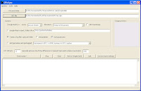
  1. Obtain and install GPicSync beta 1.27
  2. Put the photos you want to geocode in a separate folder
  3. Start GPicSync
  4. Fill in the path to your photo folder
  5. Fill in the path to your .gpx file (which includes the track and waypoints)
  6. Set any "offset" to correct the time zone differences (-8 is the difference between GMT and PST)
  7. Change the "geocode only" value from 300 to about 600 to allow a better fit for waypoints instead of tracks
  8. Press Synchronize! Sit back and watch it work.
You should probably also, check boxes for: "create log file" and "backup pictures"... just in case. AND you can even have GPicSync create a Google Earth .kml file for you, with links to all the photos and thumbnails it also creates, so you can see it in Google Earth! How awesome is that!

The only thing I've learned the hard way is that: You have GOT to save your own waypoints every time you take a picture; AND, if you stop for more than a few moments, it's best to save a waypoint both when you stop your bike AND when you finish taking pictures. That prevents the next waypoint from "stealing" photos from the end of the previous shooting session.

The program works great. It is the only one I can find for people with GPS units which don't store the time inside the track file. And, its interface with Google Earth (GE) opens up tons of other things you can do.

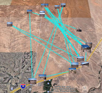
One small deficiency is that even though the .gpx file does have a good track (albeit without the times) GPicSync doesn't use it when outputting to GE. The resulting plot in GE therefore looks a bit funny - although with a neat .kml editor like jEdit you can.... But, that's another post...

I think I'll write to Mssr. Schnell again.

Saturday, February 7, 2009

Better Than Snow

There are sometimes in your life that you need to keep reminding yourself of the alternatives in order to keep things in perspective.

Like now, for instance. Mesquite Snowbirding Headquarters has been in the weather doldrums of late. The sky is overcast and it's a bit cool; but, of course what should we expect when it rains? I mean sprinkles.

Although the lake (Mead) isn't as low as it was last year, it's still at an all time low and everyone prays for rain.

When it does come, it still is a bit difficult to keep from being annoyed that the ATVs sit idle in the shed. That is, until you think of those poor souls up North... in the snow!

...So many trails... So little time...

Thursday, February 5, 2009

Old Standby Complaint - Gas Prices

Under the Obama regime there is certainly no shortage of issues one can become "miffed" to the point of outrage at. When things go great some of us miss having something to complain about; but, there is always one old standby - Gas Prices!

Our two ATVs have used up our three 5-gallon cans of gas so they needed replenishment. We nearly always try to time it so we can buy our gas while up in St. George (30 mi up the gorge in Utah.) Why? Well, lets see if YOU can figure it out.

Smiths Food King in St. George sold their unleaded gas today for $1.67/g while The Conoco (boo) in Mesquite sold it for $2.24! An incredible $0.67/g price gouge! And believe me Smith's aint always your friend either.

StoreULDSL
StG FJ1.692.17
StG Smt1.672.22
Mes Con2.242.32
Mes Mav2.112.35
Here is a list of prices for Flying J and Smith's in St. George as well as Conoco and Maverick in Mesquite. The incredible price gouge by Conoco is routine for them. To me they don't deserve a business license in the town let alone to be patronized.

So, counting my extra "10 cents per gallon discount" coupon from Smith's, the nine sawbuck's goes right into my pocket! Man, am I ready for a ride!

Wednesday, February 4, 2009

This is the Time Warp Pivot Point

Star Trek has nothing on all the gadgetry and computing going on at Mesquite snowbird headquarters. Now that I've tamed my Lowrance XOG GPS, and Mssr. Schnell has kindly programed GPicSync to accept waypoint data - I'm off and running at geocoding photos. I can even tag them along a GPS track and display the whole thing in a GoogleEarth .kml file -- huh?

A friend talked me into posting the GPS track logs I've been keeping onto a blog - and I've finally relented. This is the PIVOT POINT of the timeline. Here is today! The track diaries are posted before this and the track logs will be posted after this point. It'll make you dizzy if you think too hard about it; what it means is that if you keep going back and forth you will eventually have the whole story.

So, for awhile at least, you need to read the blog in both directions.

In addition, now that my friend has seen the blog - he wants to be able to "follow" it. Do you know what that means? I didn't until today, and I've now installed the "gadget" that allows you to do it on the blog. You can click on the buttons and sign up as a "follower" of the blog. That will notify you when a new post is made so you can keep up with it - isn't science grand?

The weather has substantially warmed - but the nights are very cold. I've got to go to St. George tomorrow to get gas - it's nearly always 40 to 50 cents a gallon cheaper, even with Utah's exorbitant gas taxes (a relic from the Olympics' "temporary tax"), than it is down here.

Tuesday, February 3, 2009

Ride 15 - Lime Kiln Cactus

Seeing an old standard ride through the eyes of a new friend makes it a new ride for all. Lime Kiln Canyon is one of our favorite rides - especially since we "bonded" with the fish.   [For a free Google Earth file of this route see: Ride 15 - Lime Kiln Canyon]

But someone new called and wanted to know where there was a good afternoon ride - so "we takes him." The thing is, that seeing it again this time helped me notice cactus that we never noticed before. We trailer'd to the White Rock Road trailhead (where it splits with Cabin Canyon Road) and headed our rigs Southeast to the mountains.

Too often . . . I would hear men boast of the miles covered that day, rarely of what they had seen.”
Louis L’Amour


There are several clumps of Pencil Cholla near the mouth of the canyon that had previously gone un-noticed. And there are quite a few more Grizzly Bear Pricklypear plants in the canyon than I had seen before. Both of these are fairly rare around this area.

We had discovered a couple of isolated plants of the "Pencil" (Cylindropuntia ramosissima) on the trail through the flats down from Middle Canyon. But here, there are many more specimens - and larger.

Additionally, I had noticed a few plants of "Grizzly" (Opuntia erinacea aka Grizzlybear P. aka Mojave P.) near the top of the canyon before; but, this ride brought out many more along the canyon trail. There were even several examples of both "regular" pricklypear and "Grizzly" growing near each other for comparison.

Not only that, we have seen "Utah Agave" plants on the Whitney Parashant side of the mountain before, at Red Pocket Tanks; but, today we saw an entire side of the canyon plush with the 5 - 8 foot, spent, flower-spikes rising through the pinyon's and cedar's. Talk about being blind... where did they come from?

The vista at the top was grand, as usual, and the ride down to the mine enjoyable through the red and yellow rocks. We had a break, then retraced our route back through the canyon.

We did, however, cut across the flats going back. Over to the Cabin Canyon road, and took that route back down to the trailer. After all, "we hates to do the same thing twice."