
That's the dilemma that we have right here on Gold Butte and if we think what the government did to native people has ended we're mistaken. The government, in the form of the BLM, still shows their avarice; but, now it's for whoever has the money – I'm looking at you Sierra Club and Harry Reid.
If you're one of the "pretty people" who still has stamina and good joints – You're the ones the BLM-Sierra has decided are deserving to be able to see the glyphs.
Or, I guess, if you're lucky enough to own a horse (just don't bring anything for them to eat cause "outside" hay might have nasty weed seeds in it) you can see them too. But, for the large portion of Mesquite residents who are seniors – "you're outta luck fellas!"
Gordon and I went down the trail last spring to just see what we could physically see; but, mostly for old times sake. [A free Google Earth file of this route is available at:
 Offroading Home.]
First Rock

Even though dad and I were told where they were and we were able to ride right up to the cliffs, it wasn't until we got off our machines and walked right up to the rocks that we saw the rock art. This is because they are some of the most ancient on the butte and the slowly growing desert varnish has nearly re-hidden them from view.
The two or three bullet holes which mar the cliff are the ones which always set the "fiends of Gold Butte" to running about flailing their arms and screaming that the whole butte is in imminent danger of collapse. They don't bother to notice that the amount of desert varnish over them proves they are a couple hundred years old themselves and were most likely the result of some old timers seeing if they could "hit that mountain over there" from back on the trail. It doesn't look to any of us like they were made with any malicious intent against the glyphs.
As the photo shows, you can't really see the glyphs from your rig on the trail. However, just walk straight ahead to the cliffs -- follow the bird crap from the eagle's nest directly above them (another bone we have to pick with the BLM and the fiends of Gold Butte).
Falling Man

Six years ago, seniors could ride up the trail to within 500 yards of the glyphs but no more. It's about a half-mile hike through the sandy trail to get up to the area, then a bit of a scramble down and around some boulders to see the "Falling Man."
And, you should know that even though it's widely talked about the Falling Man is pretty hard to see – even if you know the path down the boulders to the view point. It's really very obvious once you locate it, but it's a lot smaller than people think and above eye level, up next to the edge of the cliff on a dark spot.
Additionally, if you think that the thousands of dollars and hundreds of man hours the "wilderness volunteers" spent on the awful looking parking corral and "landscaping" extends to anything interpretive or instructional – think again padawan. The full extent of any signage are the "no vehicles" and "don't touch" placards.
None-the-less, we are happy to be able to report that all the wire cages the volunteers put around the landscaping they did, all along the tiny-pebble, girl-scout-camp pathway up to the glyphs, have finally been removed – along with all the insipid popsicle sticks containing the hand-written names of the workers that they put there.
Unfortunately, this also holds true for all the cute little plants that they planted there as well. I can't see that any of them survived their encounter.
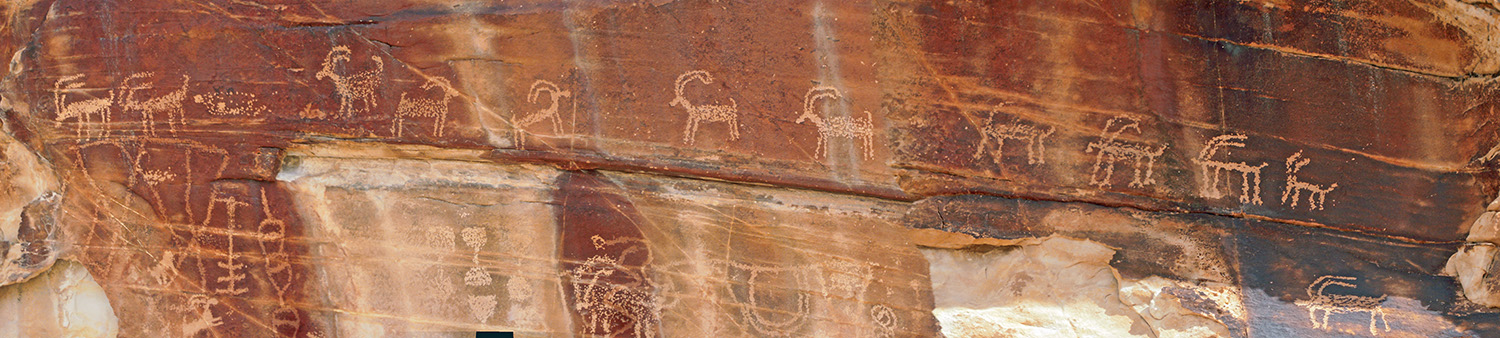
21 Goats
If Falling Man is the most well known, 21-Goats may be the least – or close to the bottom. Stop any person in Mesquite, even the old timers, and nearly all have heard of Falling Man but it's a rare citizen indeed who has heard of 21 Goats, much less has actually gone out to see them.However, until about three years ago you could ride your rigs to within a few hundred yards of a nice panel. They are still fairly pristine, minus the normal alkali leeching on the cliff walls, but now require a half-mile slog up a sand and boulder wash to get to them. More strenuous than the trail at Falling Man, this weeds out the majority of seniors and definitely anyone with knee or back issues.
Although this post isn't about any of the glyph's interpretations (or at least guesses about what they mean), the panel is truly one of the better examples. It's large and contains many glyphs in context.
Just look at the animals represented in the photo. If you have even a modest eye, you can spot the many different variations. Some "goats" are level, some tilted uphill others downhill. Some horns are arches, others right angles. Some feet are fluid and limber others like sticks and still others split in two at the hooves. Some are clearly traveling along side a pecked line or "trail" and a couple are going the opposite direction. Some horns are longer over the back and others short. Some animals are full and "fluffy" and others a straight stick-like figure. And most are "pecked" or stippled.
I can tell you that all of these variations have a particular meaning to the story as a whole; although, our understanding of the meanings are clearly minimal. The book The Rocks Begin to Speak
Good ol' DD5

It had no name back then, but was a great little trail without ANY environmental impact because it was entirely within a wash. It became one of the most favored trails for seniors because it enabled the viewing of several clusters of petroglyphs within a "loop" running through dusty desert and then through washes shaded by the surrounding hills. There were three alternative exits out onto the Gold Butte Road.
Then frantic wails of the environmentalists paying for Harry Reid's political campaigns got him to pressure the BLM to "make a finding" that the trail should be closed – that's when it got the name: DD5, so it could be written in the directive for closure.
About three years ago, the decree went out once again: "close those suckers off" and the entire trail from about a half-mile west of 21 Goats was closed making an even further back-track and detour around to the middle riding area. It's close to twenty miles further now around to Mud Wash.
And, the pathetic thing about it is that, not only did the college kids illegally block the trail in the wrong position, nearly the entire blockage is needless to "protect" the glyphs. The glyphs are not in the wash where the trail was. AND, there is a natural rock "doorway" to the alcove where the glyphs are that can be easily blocked from vehicles.
The resulting short hike could then be done by most seniors, no vehicles could get in, superfluous traffic would be avoided, back-tracking would be kept at previous levels – AND, the area could be seen by all citizens and NOT just for the Sierra Club special interest group.
Could it happen? Yes. Will it happen? Not if Harry can push through the Sierra Club's land wilderness area land grab or until Harry can get kicked out of the senate.
Until then, we can only remember what once was.
Learn A Little More
The book "The Rocks Begin to Speak" is probably the landmark text which opened this field of study to large numbers of people, and it is still in print, new or used at Amazon. Please use this link if you are going to purchase it. There is no extra cost to you, but a portion will go to keeping this site going and the trails coming.


1 comments:
I agree with you, I can't walk far anymore they are closing off roads in the Red Rocks area near Leeds, Utah. I complained to them on Facebook, but they just removed the comment. You can only see a lot of these neat places, glyphs, etc. if you not an older person. Our government is only here to work for younger people? It really gets to me. Thanks for a look at some of these areas.
Post a Comment
Thanks for taking the time to leave a comment. I will, of course, be moderating all comments to make sure (a) they conform to the standards of good taste set forth by Offroading Home; and (b) nope that's pretty much it.