Showing posts with label geocode. Show all posts

Wednesday, March 16, 2011

Offroading Home: on Google Earth

Some years ago now Google gobbled up a small upstart company whith a good idea: Panoramio. It was a company which developed software that would allow people with pictures to share – professional and wannabe alike – to geocode their shots with latitude and longitude then upload them to their servers for others to see. Their idea? To cover the earth with photos of actual places to go beyond what you could get with a flat map.

Once the company had succeeded enough to make it obvious that this was a good idea, Google made a couple of developers very rich… and happy! They bought Panoramio and added it to the growing cadre of "add-ons" to their second "cash cow" product – Google Earth.

Offroading Home has been using the service for years – it's a good place to "hang" your trip photos for others to see and the background is the actual earth instead of a wall.

Monday, October 18, 2010

NEW: Silver State Trails

The Silver State Trails in Nevada was posted about over on the Offroading Home Forum a few days ago. I'd never heard of them before, so did a bit of research and found that the trails were just a bit north of our old stopping grounds in Mesquite, up by Pioche and Pananca.

The person who posted about them left some links to pages that he had found, so I followed them.   As usual, there were no REAL, usable maps or files available; so, no-one could actually download anything but PR hype.

I found the BLM web site for the area, and one additional site which had the area split up into five of those proprietary, and nearly unusable, Adobe PDF maps.   As you know some BLM field offices are still using this "protectionist" type of format – probably thinking that what they are doing is somehow useful to people.

Tuesday, July 13, 2010

USGS Map Waypoints: Arizona

I have it on good authority that Arizona "felt left out" of what is turning out to be a major life's work for me in these western states USGS waypoint files.

Five hours of work, 43,752 waypoints (including those beginning outside the state) and Fifteen counties later… we have mappage.   [For a free Google Earth file of this route see: Arizona USGS Waypoints]

I never realized that Arizona 7th graders had it so easy in their history class when it came time to memorize the counties in the state – only fifteen. And the file size is only a tenth of California's.

Saturday, July 10, 2010

GPS Maps 104: Satellites, Spheres and Datums

[This post is part four in a multi-part series about understanding the GPS system and its coordinate grid.]

I don't know about you but had I been around in the time of the early navigators and been stuck with doing the job, I'd have been just like most of them: staying up at night trying to find a "happy accident" (like the star Polaris just happening to be squatting permanently above the north pole) in order to make the figuring out of Longitude at least bearable.

They couldn't do it. And knowing what we know now I'm sure I would have wasted my time too – with Hubble we now know that there isn't any such "short-cut". Wind up or battery driven watches seem to be the only answer for Longitude.

However, just cause God didn't give us no Geo-synchronous celestial landmark doesn't mean that we can't… or shouldn't… or haven't made up for the seeming… "oversight."

Friday, June 25, 2010

USGS Map Waypoints: California

Ok call me obsessive-compulsive. Tell me something that I don't know. And there may be a bit of some autism thrown in for good measure.

I've already released two massive Google Earth files containing the MASSIVE USGS "Features File" database for Utah and Nevada. If I thought that they were an effort – this one was (these one's were) mind-bending!

It must be something like wanting to chomp down on your dog's chew toy when you were trying to cut your own wisdom teeth – the pain of chomping your your gum somehow is perversely satisfying and feels like it "should be," if for no other reason than just to get it over with!

Friday, June 4, 2010

GEO-tography: The West

While researching for ATV-SUV map posts, I often run across landscape photographs which are so striking that they cause me to stop and look. I often don't have a place for them in an article but save them away to pull out and look at while trying to think of a next place to ride.

Once in awhile, not often enough, the photographer will have either geocoded or described the location of the image and I can look it up in Google Earth. That makes it even more enjoyable.

On the scale of what we normally enjoy to look at in photographs, items roughly rank: people we know and where we live right before where we've been and what we like to do.

In the manner of my previous "lichen" post I thought I'd dust off a few of my favorite "where we live, where we've been and what we like to do" images and see what you think. All are in the western U.S. and if you click on the author link you can see the full entry on the authors web site.

Saturday, May 29, 2010

USGS Map Waypoints: Utah, Nevada

Perhaps you know that it is the US Geological Survey (USGS) which is tasked with the responsibility of making/keeping/standardizing geographically related "stuff" in the United States.

Yes, they are the same fellows who put up those fancy brass survey markers all around the country that we see when we are offroading. They are particularly noticeable down in the Middle Gold Butte ATV, SUV riding area.  [For a free Google Earth file of this route see: USGS Utah Feature File]

Tuesday, March 16, 2010

Spanish, Mormon-Wagon and Pack-Mule Trails

People traveling through (or past as the case may be) Mesquite could possibly be wondering: "Why on earth is this town here?"

The answer, as with most other western towns, is that "because it is one days journey on horseback from the last town."   [For a free Google Earth file of this route see: Mormon Wagon Road]

Several groups of Native Americans used the route, then the Spaniards, then the Mormon Pioneers then the Gold Rushers and on and on — and all that was before they invented asphalt, concrete or Interstate systems.

A few Native American tribes actually stayed a while in the area but most were smart enough to just keep "passing through," until…

Saturday, October 31, 2009

New Background Maps For Garmin Users

As if you needed any more reason to gloat, those of you who own Garmin GPS units have yet one additional reason for being glad you do — the new Map Overlay feature just announced for the Colorado, Oregon (200, 300, 400 and 550), and Dakota models.

Unlike the rest of us who are still dependant on the "altruism" of our manufacturers to "get around" to updating our background maps – and of course pay their exhorbitant fees – you can now "update" your maps to any image that you find more useful.

To top it all off, the process uses our favorite free geo-graphic program – Google Earth. And adding insult to our already burdensome Garmin-envy, our other favorite program, GPSvisualizer, is just waiting to make your new-found ability plush with multiple kinds of maps (subject of the next tutorial).

Thursday, September 24, 2009

New Trails: Colorado North Central Region

Under the gun to see that the person who loaned me the book got it back in time — I continued the all-night vigil and hand entered more than 20 new trails in the Colorado North Central Region. All of the trail description's have also been improved and/or re-done.   [For a free Google Earth file of this route see: Colorado Trails]

Take a quick look on over to the website and see my handiwork! With the Southwestern Region done last week and the Front Range Region done last month, almost the entire Colorado map has been upgraded!

Now is probably a good time to explain how/why Offroading Home maps integrate with the written maps in the book: Colorado Trails North Central Region by Peter Massey et. al..

Friday, September 18, 2009

Doing GPS: 201 - "From GPS to Google" (Part 3)

The adventure that you planned for weeks has come to fruition and you now have only memories of sights, sounds and smells to give you solace during your work-a-day existence.

But wait, you did remember to turn on your GPS and you have the whole thing down in digital format; but, how do you look at it during your coffee break? Lets plug that thing in, fire up our software and create a Google Earth file that will fly us over the whole trail.

This week we complete our understanding of "GPS Visualizer" and make a shareable KML file which fits our own personal preferences and requirements.

Thursday, August 6, 2009

New Trail Map: Utah's Paiute ATV Trail System

After I developed the Utah Arapeen Trail System Map people began requesting that the Paiute Trail System get equal time. With all the updates recently I'm starting to feel a bit "time shared"; but, here it is — at least the beginnings. [For a free Google Earth file of this route see: Utah Paiute ATV Trail System]

I have to tell you that this effort has been quite an experience, and it isn't over yet. Unlike the Utah Arapeen ATV Trail, this trail is a bit massive — and quite disjointed (as far as obtaining and plotting maps are concerned.)

The internet-available map is NOT anywhere as accurate as the one I found for Arapeen and there are quite a few trail/number variations/differences between them.

Thursday, July 23, 2009

New Trail Map: Utah Arapeen Trail System

A few weeks back I announced that we had split our Nevada ATV rides into several separate maps. The Mesquite-Bunkerville and Gold Butte trails have been given their own files.

Well, the addition of the Arapeen Trail System has made the Utah Trails file so large that it just begged to be split — so I did. [For a free Google Earth file of this offroad route see: Utah Arapeen Trail System]

In a previous post I whined a bit that it had been quite difficult to produce the Google Earth maps of this offroad trail system. The available maps, some even produced by the USFS, were not accurate or detailed enough to produce a .kml file.

Tuesday, June 23, 2009

Geocaching: Butterfield Canyon

For larks, when I stumbled across a geocaching website, I punched in the address for Snowbird Headquarters. To my surprise it listed 162 caches within a five mile radius and 495 within 7.5 miles!

I'm going to give you the link to the site because it probably is a worthwhile site for an offroader to occasionally use; but, it'll be down at the end because, to me, it's one of those sites designed to milk the public for all they can — and do it by selling you back other peoples work.


Thursday, March 12, 2009

Dealing With Google Earth

Today, without any riding buddies, I went over to Charley's to see if we could get his Garmin GPS to behave with "Easy GPS" and Google Earth (GE).

You know that nearly every post here is accompanied by a Google Earth .kmz file which shows much more detail of our ride that I can put here. Sometimes there are also explanatory photos, and definitely more "geocoded" waypoints.

Download Google Earth

What you may not know is that GE has a new version which, unfortunately, contains several bugs. It doesn't display the pop up descriptions the same way, and they look crazy or don't show up at all.

Fortunately the 4.3 version is still available (which I still use); but, unfortunately it's not so obvious to find. Clicking on this link: Google Earth will take you to the download page, but you will need to look at the small writing and download the 4.3 version.

Turn Off "Show Time"

In either case, GE has a function to only display items which are labeled within a certain time frame. Some of your files which you load from your GPS are time coded so are hard to get displayed in GE. And the user interface is not intuitive.

It's best to simply turn off the function all together (until you really need it). To turn it off, click on "View" at the top of the screen, cursor down to "show time" and select "never" from the menu. That should do it, and all these files will display correctly.

Easy GPS

We were finally able to get his Garmin GPS files onto his computer using "Easy GPS." It's a free program which is fairly intuitive to use, and will import directly from a large number of GPS units and export to a ".gpx" file, which is now the standard, open source geo-sharing file type. You can download it from here: Easy GPS if you would like. Send me a note if you think you need more explanation.

Companion Web Site

As soon as we get Charley's files in order, I should be adding them to the master file on my accompanying web site: offroadinghome.com. If you haven't seen all those files, you should.

Wednesday, February 25, 2009

Using "OffroadingHome" KML Files

I have been asked several times how to actually use the files available free on this blog. Using them in Google Earth is easy - just click on the link and select "open"! Nothing to it.

However, until now I haven't been able to give a specific answer about how to use them inside your own GPS unit. Mostly because every manufacturer has their own proprietary file formats and instruction manuals. And also because I knew of no adequate (read reliable and free) way to convert my .kmz files to your units file types.

Today, I became aware of: "GPS Trackmaker Free." It is NOT a very "flexible" program, nor is it always "intuitive," (to a US American) nor does it support EVERY GPS unit; HOWEVER, it isn't terribly difficult to learn, it DOES read .kml (Google Earth) files, it does support a lot of brands and, most importantly, it does support the open source standard .gpx files.

All of this makes it a very useful, FREE, program which will PROBABLY do the trick, IF you have just a little bit of computer savvy. So, Charlie, here it is - finally!

Here are the steps that I have used several times now to download a track file from this site, convert it into my Lowrance GPS file type (.usr) and then read it with the Lowrance mapping software. It should also work with other brands such as Garmin and Magellan (some), and does provide an apparently unique interface between .gpx, .txt, and .kml file types which can then be used in other "converters."

The procedure is a bit circuitous and uses both the Google Earth and GPS Trackmaker programs. "Earth" to change the file from compressed to un-compressed (.kmz to .kml) and "trackmaker" to change it from .kml into a, hopefully, useable type for your GPS unit (ie. .kml to .usr).
  1. Download and install Google Earth (4.3 version) and learn how to "OPEN", and "SAVE AS" a track file into the .KML format. The 4.3 version doesn't have the bugs that the new 5.0 version has.

  2. Download and install GPS Trackmaker Free and familiarize how to "OPEN" .kml files and "SAVE AS" the file type of your GPS unit (your literature should tell you what it is).

  3. Create a new working folder somewhere that you can find easily, like your desk top.

  4. Open the "OffroadingHome" blog and find the trail you want to convert. Then click on the file link and choose "OPEN" when requested.

  5. The file will open Google Earth and will be listed in the "temporary places" folder (above). Cursor over the file name such as "16th Day.kml," RIGHT-click the link and choose "SAVE AS."

  6. The "save file" dialog box will open and will need some changes.
    First, the "save as type" must be changed from .kmZ to .kmL;
    Second, the "file name" will have a .kml ending (16th Day.kml) which must be taken OFF (as shown);
    and Third single-click on the conversion folder you have set up (in order to highlight it as the place for it to go) then click "Open" followed by "Save."

  7. Google Earth will have now saved the compressed .kmz file from my site to an un-compressed .kml file in the folder on your computer. Now you can close Google Earth and open GPS TrackMaker.

  8. From the menu at the top select "File > Open File." Then from the "Open File" dialog box, navigate to your conversion folder, select your file and press "Open." The file will now be inside TrackMaker and ready to convert. In this example you can see the track and two waypoints.

  9. Now, go back up to the top and select "File > Save As" to open the standard dialog box. You MUST change the "Save as Type" box to the file type that YOUR GPS expects, in my case the Lowrance ".usr" type. Also navigate to the conversion folder and set the file name the way you want it.

  10. Press "Open" then "Save" and my file has been converted into your GPSs type.

  11. Now, follow the directions that came with your GPS unit to move the file you just created back into your GPS unit. You should also be able to open the file with any mapping software that came with your unit.

Some people without brains do an AWFUL lot of talking!”
L. Frank Baum
The Wizard of Oz

The file type ".gpx" is known as the standard open source protocol for geo-coding. Many other programs (including Google Earth), and some GPS units will accept a file in this format.

The whole process of doing this is sort of like an enema - "it feels sooo good when it's over." But it does work and the next time you go riding you will have the track to follow and waypoints to look for. I would appreciate comments from anyone who uses this for their units - or anyone who had a better way.

Monday, February 16, 2009

Ride 17 - Mesquite City

Nothing like staying close to headquarters on a blustery day. It was supposed to rain (yet again) in the afternoon but we had stood being cooped up for as long as we could handle. [For a free Google Earth file of this route see: [Ride 17 - Mesquite]

We had been meaning to "test" Mesquite's newly passed (and hotly debated) ATV law. There was so much rhetoric about the thing that it was hard to say what was real and what was not. Apparently, the city "fathers" (does this still hold if the mayor is a woman?) have been saying all along that ATVs could ride along the river; but, the BLM was reported to have disagreed.

The city also claimed that there was cross city access through the city's drainage ditches. Riders, however, claim that the gates to them are all locked and bike/walking trails have signs posted against motorized vehicles.

Clearly, by state law (and enabling city legislation), ATVs are supposed to be able to navigate all the city's streets EXCEPT Mesquite Boulevard, Pioneer Boulevard, and Riverside Drive. Rigs MAY cross those streets (if you dare), but not ride along them. And, of course, I-15, which bisects the city, is verboten; as well as your head MUST be covered under DOT approved plastic.

So, we left Snowbird Headquarters in fearful anticipation and attempting three goals: to quantify where the "legal" roads would allow us, to see if we could ride along the river, and to see if we could ride across town to the Northside Flats trailheads from Southwest Mesquite.

I'm happy to say that we accomplished all three goals, albeit not without a substantial amount of negotiation and back-tracking.

From headquarters we rode on 2nd South to the bike/walking trail and because there was no sign prohibiting it, rode along the dirt shoulder across Hafen Lane and down to the river. So far, so good. There were trails along the river which we could ride in both directions, we chose East.

You can tell the Virgin River has changed its course over the years. About even with "Thistle Avenue" there was obvious work at reclamation, as well as fences and signs telling you so.

About even with "Laurel Way" the trail along the river turns North and enters the city's drainage system. A trail does go up out of the wash but only to a closed in dirt area.

We headed up the culvert. At Mesquite Boulevard (by Ace Hardware) you need to climb over some rocks and up into the cement tunnel - not bad. However, at Old Mill Road the boulders the city has place there are too big and oddly placed to negotiate without damage to one's rig. There are a couple of tracks where people have climbed up the embankment and onto the sidewalk at Desert Drive.

Across Old Mill Road, another dirt area provides a way to get back down into the ditch on the other side of the blockage. The next thing you know, after a very interesting ride through a long, noisy and musty tunnel, you are on the other side of the freeway.

Thanks to the interstate highway system, it is now possible to travel across the country from coast to coast without seeing anything.”
John Steinbeck

You could continue North, but that would only get you up to Pioneer; so we climbed out of the wash onto the Southwest corner of the Virgin River Casino parking lot. We navigated around the outside of the parking lot and up to the stop light at Mesa Boulevard and Pioneer.

As nice as you please we just joined the Que of automobiles waiting on the semaphore then rode, turning heads, across the street and up Mesa Boulevard to the trailhead.

Just for completeness sake, we wanted to see how far up North that trail would take us (thinking of our previous two failed attempts to find the Northeast passage). The answer was: "not far."

We rode up along peoples property lines (which must not make them too happy) until we arrived at the Northeast end of an airport runway. Then down, around and up to the edge of a large canyon area, which just happens to be the 19Th hole of a pretty serious golf course.

Finding no way up and around, we retraced back down to the river and rode West to the Riverside bridge. With all the construction and traffic there is really no way to get either across or around the area.

We tried several other paths to get up off the river bank but they eventually were found to be signed against motorized vehicles. It was confusing, and we may have gotten it wrong, but we ended up on Hafen and from there up Thistle and back to headquarters.

Thursday, February 12, 2009

Rainy Daze

It's comming up on spring fast, here in the desert - and everyone is VERY happy around Snowbird Headquarters that it's raining.

I say AROUND the headquarters, cause those IN the headquarters are a bit grumpy. We do love rain, and we are very happy to see the child-like gleam of near Ecstasy in all our friends eyes who have been praying for lo these many months; but - as I keep telling people: so many trails, so little time!

Our Nature lies in movement; complete calm is death.”
Blaise Pascal

So to try and shake the cobwebs from my brain I've been doing a ton of "updating" over at the web site: http://offroadinghome.com/.

The Nevada section has three files now. "Nevada Trails" - for SUV/ATV trails all over the state; "Mesquite-Bunkerville" - for those trails around Mesquite, and for this years travels (they will be moved later); and, "Gold Butte Petroglyphs" - for those trails down on Gold Butte.

In addition, I've found a new server to store the Google Earth files on which gives a much faster download, AND doesn't require any of the kloodgey junk that my ATT server used to inflict on everyone.

These entries here still will have the individual trails that we go on and my witty narrative descriptions. But, the files at the web site have ALL the trails in one place, and lots more placemarks for locations so you can see a better overview. You picks yer choice.

Click on over and give it a try why don't you? Send me an email if you have any problems. And be sure and leave a comment or two so I can tell what types of trails that you would like to see more of.

Monday, February 9, 2009

Geocoding - GPicSync

We've talked before about my quest to more efficiently document the trails, tracks and waypoints we take on our trips. With the air blustering through the cracks in Snowbird Headquarters, ducks swimming up the street and snow in the mountains - now seems like a good time to talk some more!

Nearly everyone has access to a digital camera now days. Even the kids use the one on their phones in ways none of us older guys ever even thought of. Each photo taken is a "file" stored somewhere with a name.

Unfortunately, there are still many, many types of files. Meaning many different styles for storing the same data - depending upon manufacturer of the camera and whether you want "quality" versus "small size."

Fortunately, they do have something in common and that's a very small area accompanying the photo data file called a "header." It's a secret place to store "directions" in the file, to tell the computer how the data is organized so it can get it back out. This is also the place that cameras can store the date and time the photo was taken. AND, the place to "sneak in" GPS data!

Some cameras even store GPS data automatically - mine does not, and probably neither does yours. We do have another way, however, and that's to get the latitude and longitude from another source and have your computer "poke" them into the picture file when you get home.

Also, as I've spoken about before, I was naive enough to buy a Lowrance XOG GPS without realizing that it used "non-standard" methods in storing its tracks.

The "standard" is to automatically store the latitude, longitude, time and sometimes altitude in a long list every few seconds. That way, your mapping software just plots a dot for each of the thousand records in the list, and voila you have a trail.

Unfortunately, the Lowrance XOG decided to strip off the time from the record so you can tell where you were but NOT when you were there. So you can't tie your photos to your GPS using TIME! [The XOG doesn't save its file in the standard ".gpx" format either; but there is an easy way to get around that - in another post]

Fortunately, a saving grace, albeit extremely annoying, is that the XOG does store the time when you press the button and save a Waypoint. That's just an expanded track point saved in a separate file, so you can record a "flag" of a "special" place you wanted to remember.

The problem was that absolutely none of the programs available to "poke" the coordinates into photos even looked at the waypoints, they only used the tracks. That's where GPicSync comes in.

When I discovered the problem with the Lowrance XOG, I had the temerity to write to François Schnell at his home in France. He agreed that it would enhance his program to add that functionality and sent me the beta copy. It works great! Once you drill it into your head that you MUST manually set waypoints every time you get off your bike to take a picture!!!

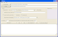
I can now geocode my photos - and you can too:
  1. Obtain and install GPicSync beta 1.27
  2. Put the photos you want to geocode in a separate folder
  3. Start GPicSync
  4. Fill in the path to your photo folder
  5. Fill in the path to your .gpx file (which includes the track and waypoints)
  6. Set any "offset" to correct the time zone differences (-8 is the difference between GMT and PST)
  7. Change the "geocode only" value from 300 to about 600 to allow a better fit for waypoints instead of tracks
  8. Press Synchronize! Sit back and watch it work.
You should probably also, check boxes for: "create log file" and "backup pictures"... just in case. AND you can even have GPicSync create a Google Earth .kml file for you, with links to all the photos and thumbnails it also creates, so you can see it in Google Earth! How awesome is that!

The only thing I've learned the hard way is that: You have GOT to save your own waypoints every time you take a picture; AND, if you stop for more than a few moments, it's best to save a waypoint both when you stop your bike AND when you finish taking pictures. That prevents the next waypoint from "stealing" photos from the end of the previous shooting session.

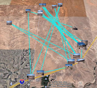
The program works great. It is the only one I can find for people with GPS units which don't store the time inside the track file. And, its interface with Google Earth (GE) opens up tons of other things you can do.

One small deficiency is that even though the .gpx file does have a good track (albeit without the times) GPicSync doesn't use it when outputting to GE. The resulting plot in GE therefore looks a bit funny - although with a neat .kml editor like jEdit you can.... But, that's another post...

I think I'll write to Mssr. Schnell again.

Wednesday, February 4, 2009

This is the Time Warp Pivot Point

Star Trek has nothing on all the gadgetry and computing going on at Mesquite snowbird headquarters. Now that I've tamed my Lowrance XOG GPS, and Mssr. Schnell has kindly programed GPicSync to accept waypoint data - I'm off and running at geocoding photos. I can even tag them along a GPS track and display the whole thing in a GoogleEarth .kml file -- huh?

A friend talked me into posting the GPS track logs I've been keeping onto a blog - and I've finally relented. This is the PIVOT POINT of the timeline. Here is today! The track diaries are posted before this and the track logs will be posted after this point. It'll make you dizzy if you think too hard about it; what it means is that if you keep going back and forth you will eventually have the whole story.

So, for awhile at least, you need to read the blog in both directions.

In addition, now that my friend has seen the blog - he wants to be able to "follow" it. Do you know what that means? I didn't until today, and I've now installed the "gadget" that allows you to do it on the blog. You can click on the buttons and sign up as a "follower" of the blog. That will notify you when a new post is made so you can keep up with it - isn't science grand?

The weather has substantially warmed - but the nights are very cold. I've got to go to St. George tomorrow to get gas - it's nearly always 40 to 50 cents a gallon cheaper, even with Utah's exorbitant gas taxes (a relic from the Olympics' "temporary tax"), than it is down here.